A closer look at the Armenia-Azerbaijan border deal

On April 19, Armenia and Azerbaijan reached a historic agreement to demarcate a section of their state border for the first time. This agreement came after a month of tensions surrounding four non-enclave villages (Bağanıs Ayrım, Aşağı Əskipara, Xeyrımlı, and Qızılhacılı) in the north-western Qazax District of Azerbaijan, which have been under Armenian control since 1992. Approximately 2,000 people were displaced from these villages, which have remained deserted ever since. In this region, both countries control parts of each other's territories; however, apart from the enclaves, this is the only part of the border where one state controls settlements within the mainland of the other.
The text of the agreement, along with subsequent responses from the Armenian Prime Minister's Information Department to local media inquiries, addresses several key issues that have largely been overlooked by media. This article will provide a detailed examination of these points.
Return of territories
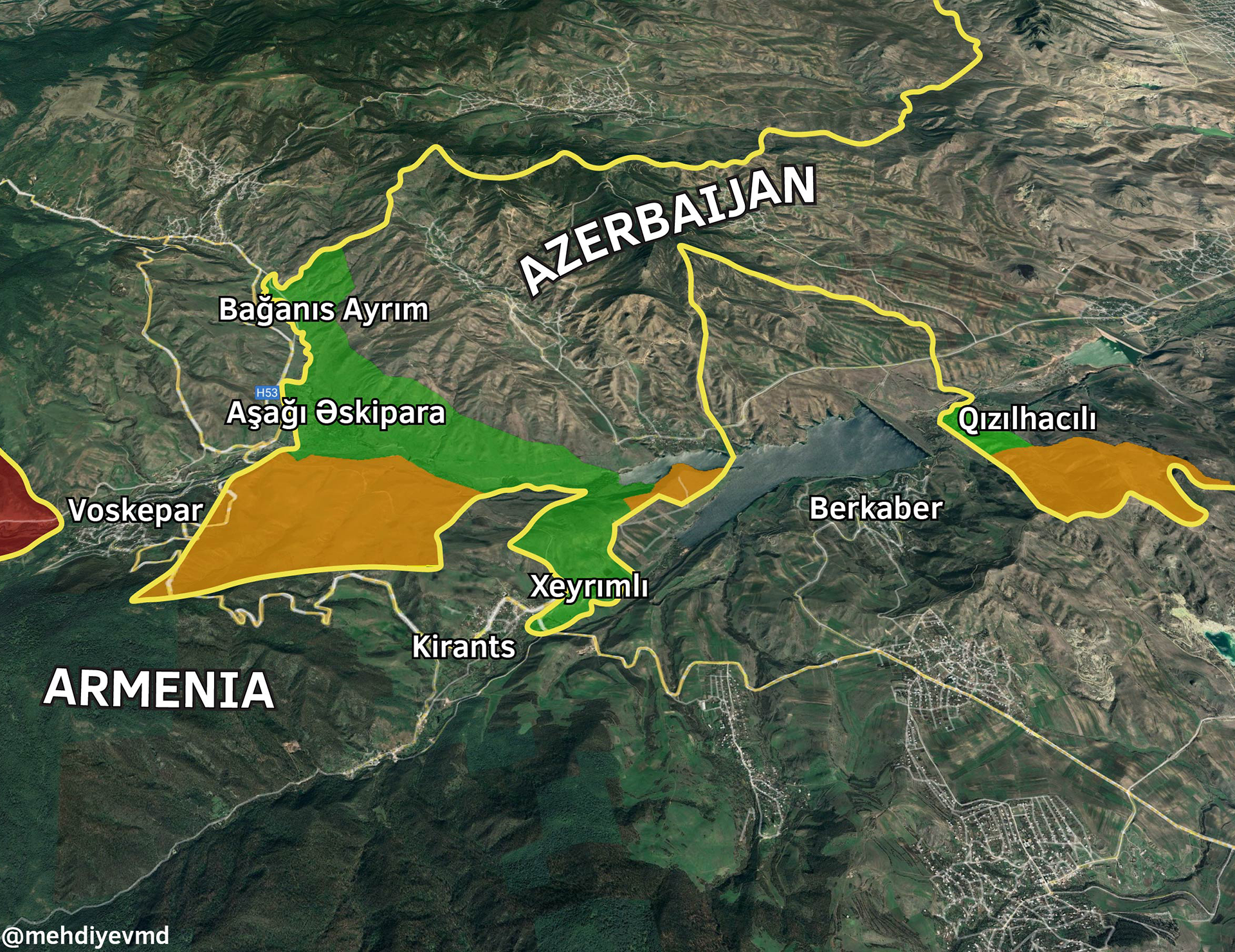
While the new agreement mandates that Armenia will return the four villages to Azerbaijan, not all areas will see a complete restoration of the border in this initial delimitation process. Armenia will maintain control over three main Azerbaijani territories until further delimitation occurs: the hills south of Aşağı Əskipara, which the M16 Armenia-Georgia highway traverses; a small section around the Joghaz Reservoir; and the hills south of Qızılhacılı, which provide a vantage point over the nearby Armenian village of Berkaber.
Conversely, Azerbaijan will retain control over the region it currently governs north of the Joghaz Reservoir, between the Məzəm and Qızılhacılı villages, until further talks take place.
Map 1. Territorial changes according to the new border deal

Highway issue
One of the primary concerns for the Armenian opposition regarding the village returns is the M16 highway's passage through Azerbaijani territory. This highway is crucial as it is one of the roads that connects Armenia with Georgia and serves as the main route for several villages in Armenia's north-eastern Tavush region.
As part of the deal, Armenia retains control over the most challenging segment of the highway to reroute, specifically the section near Voskepar village that ascends a mountain. Any rerouting would require constructing the road on an even higher elevation. However, this is not a significant problem since alternative dirt forest roads are already present, circumventing Azerbaijani territory.
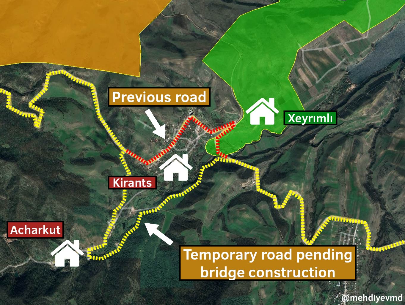
In the recent agreement, Azerbaijan will gain control over only a minor portion of the highway near Kirants village, where a bridge is located. The Prime Minister's Information Department has assured that a new bridge will be constructed within the next few months, and until then, there is an existing detour through the adjacent village of Acharkut.
Map 2. Road situation around Kirants village

Official misinformation
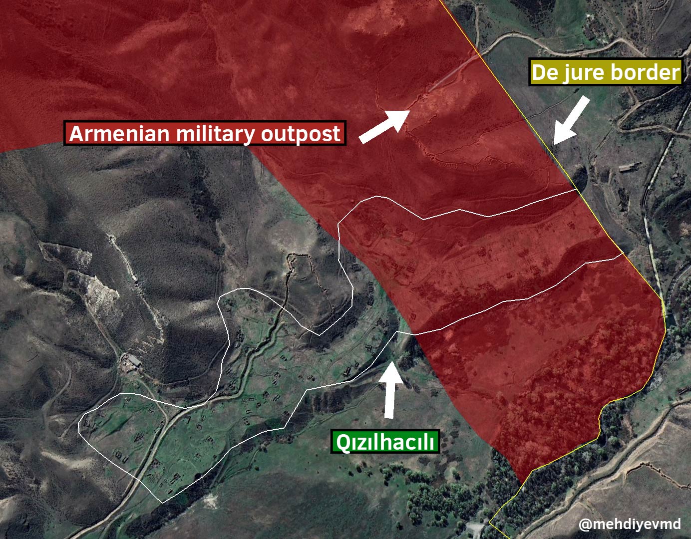
In response to the questions, the Information Department reiterated a claim by Armenian Prime Minister Nikol Pashinyan that entire territory of one of the four villages, Qızılhacılı, and "a significant part" of Aşağı Əskipara was under Azerbaijani control. However, the reality is that while Azerbaijan does control approximately half of Qızılhacılı, there are still Armenian military posts in the village. Furthermore, contrary to the claim, Azerbaijan does not control any part of Aşağı Əskipara, and there are Armenian military posts situated within the village.
Map 3. Military situation around Qızılhacılı

Importance of the border deal
The historic agreement quickly garnered commendations from various actors, including the United States, Germany, Sweden, Türkiye, the European Union, and the United Nations. In a conversation with local media on April 20, Pashinyan declared, “Armenia and Azerbaijan have resolved the issue at the negotiating table for the first time”.
The decision to return the Azerbaijani villages was not well-received by some Armenian analysts and residents of neighboring Armenian villages, who staged a protest on April 20 by obstructing sections of the M16 highway. A prevalent argument was that Armenia was giving up these areas without receiving any territorial concessions from Azerbaijan for the fields and hills within Armenian territory that it controls. However, the perspective that returning the homes of displaced individuals who are still alive should not be contingent upon a concession is also valid. The fact that Azerbaijan only demanded the houses under Armenian control, leaving other border areas for future negotiations, can be seen as a concession in itself. The emotional toll associated with the occupation of homes from which people have been displaced is arguably far greater than the significance of some fields and hills.
The reconstruction of these long-abandoned villages will likely take more than a year. However, once they are repopulated, these settlements will be the nearest Armenian and Azerbaijani communities along the state border. The manner in which the inhabitants of these adjacent villages engage with each other, if they do at all, could be instrumental for future endeavors towards Armenian-Azerbaijani reconciliation. During the Soviet era, these villages had a strong trade relationship. In a recent conference with the locals of Voskepar, Pashinyan highlighted the significant importance of revitalizing these connections and conveyed the exciting prospect of reestablishing trade with these Azerbaijani villages.
Map 4. Map of nearby settlements in the Qazax-Tavush region

The demarcation of the state border has been a contentious issue in the peace talks between Armenia and Azerbaijan. However, this fresh progress suggests that we may witness comparable agreements on border demarcation in other regions, significantly contributing to a potential peace accord.


